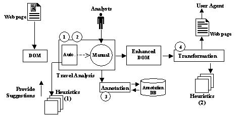
Figure 1: The proposed architecture of the mobility support tool.
This paper presents a description and evaluation of a framework that enables the analysis of travel support offered by Web pages. This travel analysis framework will provide the basis of a tool that encapsulates a technique for the support of travel upon the Web.
Harper [11] introduced the notion of travel and mobility on the Web to improve the accessibility of Web pages for visually impaired and other travellers by drawing an analogy between virtual travel and travel in the physical world. Travel is defined as the confident navigation and orientation with purpose, ease and accuracy within an environment, that is to say, the notion of travel extends navigation and orientation to include environment, mobility and purpose of the journey. Navigation suggests an opportunity of movement within the local environment. Orientation is the knowledge of the basic spatial relationships between objects within the environment, and the objects and the traveller. Mobility is the ease and confidence at which travel can be accomplished. Environment is the context in which the traveller journeys through and includes the way the landscape is rendered and perceived [9]. Travel objects are environmental elements that are used during a journey; in the Web, they are supplied by the page design and the browser.
Visually impaired people have difficulties accessing the Web, either because of the inappropriately designed Web pages or the insufficiency of the currently available technologies. This lack of accessibility leads to poor travel support for visually impaired users. Visually impaired people usually access the Web, by using screen readers [13] or specialist browsers [2]. For these access technologies to work properly, Web pages must be appropriately designed and must be encoded in valid HTML that conforms to its DTD (Document Type Definition) and various accessibility guidelines. The W3C Web Accessibility Initiative and others, recognise these difficulties and provide guidelines to promote accessibility on the Web [5,10]. Unfortunately, not many pages are so designed. Additionally, these access technologies have focused on supporting the sensory translation of visual content to either audio or touch (through braille) rather than deeply affecting travel on the Web [12].
Our main goal is to provide tool support for enhancing travel on the Web - moving the travel component from a craft towards an engineering paradigm. The aim of this tool is to analyse the travel support offered within a Web page and semi-automate the process of:
Before we can devise such a tool that encapsulates the components above, we need to capture the travel analysis process in a framework. Although Harper [11] has proposed a mobility analysis framework, the focus is on providing a mobility rating which shows the mobility support of the page being analysed. In practice, this framework proved to be inappropriate and insufficiently detailed to be the basis of our tool. Although it is a useful start, the framework needed to be modified and extended as it is intended to be used by designers. Consequently, it is ‘craft based’ and requires to be systematised so that it could be encoded into a semi-automated tool. In this paper, we will explain the extended and modified framework.
The travel analysis framework consists of the following two stages:
These stages capture the first two components of our tool. Figure 1 illustrates the proposed architecture. The travel analysis framework will be the core for the development of other two components. They will be built upon the implementation of the framework. The proposed tool is described as ‘semi-automated’, because it is intended that the analysis framework, when captured within the tool, can extract and classify travel objects with no human intervention. This will, in all likelihood, be sub-optimal. The automatic extraction will often form the basis for human intervention to optimise selection of travel objects and their classification. Therefore, the framework developed must be usable both by humans and machines.
Automatic implementation will be based on heuristics, derived from the framework, that will enable identifying and classifying travel objects. The intervention will be the manual implementation of the framework by an analyst. This could be needed because:
This paper also presents the evaluations of the framework. They were conducted to test the systematic notion of the framework. We tried to demonstrate that the travel analysis process in the framework can be applied automatically as well as manually.
Figure 1: The proposed architecture of the mobility support tool.
This paper is structured as follows: Section 2 describes the extended and modified model of real world travel and the travel analysis framework. Section 3 explains the evaluation of the framework. Finally, Section 4 offers some conclusions and suggests some future steps to be taken.
Travellers use or may need to use environmental features or elements in order to make a successful journey. We call these features and elements travel objects. Travellers use landmarks and memory objects to reassure themselves that they are safe to proceed and going the right way. Landmarks and memory are two main classes of travel objects, and these classes also include sub-classes which are as follows [9]:
These classifications are dynamic and can overlap. An identification point is both a landmark and a memory object. A landmark may be classified as an information point and a way point on closer inspection. This classification depends on the context of the travel. The traveller navigates and orientates by consulting memory objects, and detecting and identifying landmarks. Consultation, detection and identification are accomplished through the mobility instruments of in-journey guidance, previews, probes and feedbacks. These components form the model of real world travel [9].
Our mobility support tool will encapsulate this model of travel. Fundamentally, the encapsulated process will be based on extracting travel objects from the environment in which travel takes place - a Web page. Therefore, before we can extract them, we must identify such objects and specify their characteristics. These have to be in detail and must reflect the key environmental features used by travellers. This means modifying and extending [9]. The extensions and modifications lead to have three broad categories of travel objects: (1) way points, (2) orientation and (3) travel assistants. These broad categories also include sub-classes and in the following sections, we will explain them in detail. The inventory of travel objects and characteristics can be used as the basis for the heuristics that will enable the classification of travel objects. These heuristics will be encoded in the tool.
Research on the mobility of visually impaired people in the physical world, wayfinding, spatial orientation, urban and architectural design suggest that visually impaired or sighted travellers use a variety of sources of information during a journey [17,19]. We will here highlight the key travel objects and their characteristics. Table 1 shows these objects and examples from the real and Web world.
Table 1: Travel objects and examples from the physical and Web world.
| Role | Real World | Web | |
|---|---|---|---|
| Way Points | Decision Points (DP) | Junction, corridor intersections. | Menu, check boxes, and combo box. |
| Way Edge (WE) | Wall, shorelines, hedges, fences, cliffs, railroad tracks [17], edge of lawns. | Colour boundaries, frame borders. | |
| Navigation Points (NP) | Streets, walkways, canals, railroad [17], corridors and some examples specific to buildings: stairs, escalators, elevators [19]. | Hyperlinks, mail to, search box. | |
| Identification Points (ID) | Building name, house number, street name, campus entrance identification, floor number. | Heading, title, URL, frame title. | |
| Alert (AL) | Traffic lights, signs that identify hazards, bridges, stops, and curves. | Progress bar, a search field icon can change the color and appearance to indicate that the search is in progress, displaying or animating an hour glass. | |
| Attention (AT) | Advertisements. | Animation, advertisement, banner. | |
| Reference Points (RP) | Big Ben, Precinct centre bridge on Oxford road [19], sculptures, structural or decorative elements, information booths, and etc. | Logo, title banner, some aspect of the style. | Orientation |
| Location & Position (LP) | “You are here” signs, signs that show the current position, reassurance signs on the motorway. | Hyperlink menus highlight the active page, some sites show the active page | |
| Direction (DR) | Signs that show the direction to cities, towns, signs with arrows. | Scrollbar direction, Back and Forward button. | |
| Distance (DS) | Signs that show the distance to cities or towns. | Scrollbar (distance from top & bottom of the page). | |
| Travel Assistant | Information Points (IP) | Information or help desk, police, friends. | Search Box. |
| Travel Aid (TA) | Map, tactile map, road list, floor plan. | Site index, table of contents, site map, outline. | |
| Travel Memory (TM) | Route plan, journey plan. | Previously visited links change colour, history list, bookmark. | |
| Travel Support (TS) | Guided tour, visually impaired individuals may learn new routes by guiding them. | Guided tour. |
These are the points within a journey at which a decision may be made that directly facilitates onward movement. Below, we explain the sub-classes of way points (see Table 1), however other classifications may also be considered as way points depending on the journey undertaken:
Decision Points are the choice points where alternative paths of travel are possible.
Travellers recall the direction they must travel to reach their destination and they change their direction of travel
if necessary [16]. At decision points people have to choose from different
paths.
Way Edges are the environmental elements that are linear or continuous and act as
boundaries between two areas [17]. Visually impaired travellers, during a
journey, usually make exclusive references to these elements in the environment [8].
Navigation Points provide a possible route and the traveller exercises some control by
choosing to follow or not to follow it. They can be considered as decision points in wayfinding, but the traveller is
not choosing from a set of options; the traveller needs to decide to follow or not to follow it. They relate directly
to the paths that are defined as channels along which people potentially move [17].
Reference Points or Landmarks are some aspects of the environment that are unique and
memorable [17]. They are defined as the most salient cues in any
environment [6] and are conceptually and perceptually distinct
locations [15].
Increased usage of landmarks or reference points is one of the strategies used by visually impaired people to travel efficiently in their homes and communities [16]. Landmarks have to communicate some specific, identifiable features [20]. They may be primarily physical objects, but they can be sounds, odours, temperature or tactual stimuli [4,16,20].
Reference Point Components are directly related to the information points and are defined
as two or more stimuli that, when linked, allow a traveller to determine his or her exact location [16]. A single reference point component might not be enough to identify the exact
position of the traveller him or herself. Whereas, when two or more reference point components are linked, a traveller
can determine his or her exact position. They are common features which do not provide precise position. However, they
might help in determining one's general position.
Identification Points are identification signs that are elementary state description of a
location and usually perceived when the destination is reached [19]. These
points identify an object, a place or a person in the space.
Identity is what makes one part of an environment distinguishable from another; it is a characteristic that allows the traveller to differentiate parts of the environment [1]. Travellers can use identification points to validate their arrival at the destination (“this is it”).
Attention These are the objects that attract traveller's attention and may change the
traveller's focus. They may be used for observations that may lead to interesting discoveries but yield most
initiation control to the environment [18].
Alert These objects alert the traveller to a change in the environment or control of the
journey [9]. Like the attention objects, they also attract the traveller's
attention, but they usually notify approaching action or danger.
Orientation is defined as the knowledge of one's direction and distance relative to things observed or remembered in the surroundings and keeping track of these spatial relationships as they change during locomotion [3,4]. The concepts* of position or location, directionality and laterality are important cognitive components for orientation during mobility [16]. Moreover, as one moves towards a desired goal, establishing orientation and maintaining orientation are critical components of successful travel.
The knowledge about orientation suggests that a person needs information about location, distance and direction in order to be oriented in a journey. Landmarks are used to give sense of location [14] and are defined as spatial anchors since they provide precise information about one's location [16]. Landmarks are also important for the orientation of visually impaired travellers [3].
Direction Directional information is essential to the navigator's ability to remain
oriented within the environment [7,17]. A sense of direction that is an ability to maintain direction while moving, is
usually equated with a sense of orientation [19]. Directional information
can be provided through the directional signs that designate direction towards a place, an object or an event in form
of a name, symbol or pictograph and an arrow. They may also show which direction the traveller is moving along.
Distance The ability to make accurate distance estimations facilitates establishment and
maintenance of orientation [16]. Objects that provide distance information
may indicate distance from the traveller's starting position or from the traveller's destination. They may also show
where one is with respect to nearby objects and the target location.
Location or Position Landmarks provide implicit location or position information, because
the different travellers may have varying amounts and type of information about landmarks. However, there may be some
objects in the environment which provide location or position information explicitly. Location or position objects are
directly related to reassurance signs and are defined as checkpoints which are used by travellers to reassure
themselves that they are on the right track [19].
Sighted or visually impaired travellers may all experience problems in orienting themselves from time to time in an unfamiliar or familiar environment. They use different strategies for solving this problem including consulting a map; exploring the space systematically, either alone or with a guide; or following verbal or written directions [16].
Information Points are medium from which a traveller can directly request information. The
traveller controls the type and amount of information requested and supplied, so they are active information
supply [16].
Travellers can update their spatial information by interacting with other people while travelling. This is one of the strategies used by travellers for re-orienting themselves [16]. A supportive environment can be thought of in terms of information points at frequent and regular intervals. Particularly, information points may be important for visually impaired travellers, since they compensate for not having access to distant cues that are so useful to the sighted travellers [21].
Travel Aids provide an overview of the environment. They usually place the entire
environment within the traveller's view. We refer to them as passive information supply, because, unlike information
points, the traveller does not control the type and amount of information. They can also be considered as secondary
sources, which can be used for spatial knowledge acquisition. They may help travellers to determine their position in
the environment, their direction of travel, and the relative position of other objects or places in the
environment [6].
Travel Memory holds information about where the traveller has been and provides means to
get back there. It can be considered as an external memory aid to supplement internal memory [9].
Travel Support A traveller may make a journey without controlling all the details of the
journey, that is to say, the traveller may not actively control the journey undertaken. Travellers may make a journey
by actually being guided throughout. This could be a strategy for travellers to learn the spatial relationships in an
unfamiliar environment [6].
If we look at the Web landscape from the real world travel perspective, the travel objects explained above also exist in the Web landscape (see Table 1). The Web landscape is defined as the combination of the page and the agent (e.g., browser) [9]. The travel objects play an important role in the mobility of the Web users. Particularly, since the Web landscape of visually impaired users do not present travel objects appropriately, their mobility is reduced. The travel objects should be presented in a way that they can fulfill their intended roles and ease travel on the Web.
In the first part of the framework, Web pages are analysed to find out the provided travel objects and create a travel object inventory. The aim of identification is to filter the page and find the objects that are useful in promoting the onward journey. These objects are the regions or portions of the page. These can be the result, in the rendering, of HTML elements, collections of HTML elements or parts of elements. These objects can be placed in a structure, that describes the travel about a page. A journey should be made by noting which parts of the page (rendering or underlying code) are useful in promoting the onward journey. These then become the travel objects.
We have developed a set of guidelines for identifying the travel objects within a Web page. These guidelines are established by investigating a large number of Web pages. They are designed to be used during the manual travel analysis process that will be encoded in our tool. Moreover, the aim is to make the identification process systematic and consistent. If the process is proved to be so, the guidelines may form the basis of heuristics for travel object identification within the automated part of the tool. These heuristics may also evolve throughout the application. The guidelines are principally grouped into four. We will summarise these groups and present some examples for each:
The second part of the framework aims to classify the extracted travel objects. The main use of this classification is to discover the roles of each travel object in the inventory. Every travel object has at least one role during a journey and depending on the journey, it may have more than one role or it may have different roles in different journeys. Since we cannot consider all the different possible journeys, we only consider the possible roles of travel objects in a general context.
The classification process consists of a series of questions that have to be answered for every object in the created inventory. The expected answers to the questionnaire are yes or no. This is to simplify the process and make it systematic. The results are then evaluated to infer the possible roles of the travel objects. The aim of asking every question to every object is trying to decrease the subjectivity and provide a systematic approach to classification. In the automated part of our tool, the heuristics will be developed from the proposed classifications of travel objects (see Table 1) and also from the questionnaire.
The purpose of the evaluation presented here was to test whether the proposed travel analysis framework can be used to analyse the travel support offered within a Web page.
Two evaluations were conducted: First analysing the Google Directory page and second the home page of the Royal National Institute of the Blind (RNIB) by using the framework. The same process was followed in both evaluations and can be summarised as follows:
If the users of the framework would be able to create a travel object inventory, classify travel objects and the results would be consistent between users , then we would be able to design a tool to support this framework.
Twelve participants were used in the first evaluation (referred to as P1-P12). All the participants were experienced Web and HTML users. They had created at least one Web site before. In the second evaluation, six of the twelve participants of the first evaluation were reused.
In the first evaluation, twelve participants analysed the Google Directory page. This page was used because the design is simple, navigation based and provides many travel objects. We did not want to use a complex page and confuse the participants, because they were not familiar with the notion of travel and did not have experience in identifying the travel objects. Moreover, it is obvious that it was not designed with accessibility in mind.
In the second evaluation, six participants analysed the RNIB home page. Compare to Google Directory page, this page has a linear structure, it is more text-driven. While the design of this page is not as simple as Google Directory, the main design focus of this page was providing accessibility.
The same procedure was followed in both evaluations. We first explained the problem domain, the goal of the framework and discussed some accessibility issues with each participants. We also explained the notion of travel on the Web and mobility. Then we asked them to apply the framework as follows:
After the participants completed applying the framework, we asked them a set of questions concerning the overall usability and efficiency of the framework. They are rated on a 5 point rating scale, 1=very difficult (not useful at all) and 5=very easy (very useful).
Both evaluations were successful in demonstrating the applicability of the framework. The participants were able to create inventories of the travel objects on both Web pages and classify the travel objects in their inventories. The created travel object inventories were highly consistent and were able to demonstrate that the encapsulated process in the framework is systematic.
Table 2 shows the analysis results of the Google Directory page of Figure 2. Similarly, Table 3 shows the analysis results of the RNIB home page of Figure 3. On average, each travel object on the Google Directory page (Figure 2) was extracted by 84.8% of the participants and this average increased slightly in the analysis of RNIB home page (Figure 3) to 88.8% (see Table 3). While most of the extracted travel objects were common in the inventories of all the participants, there were also some objects that were considered at different granularity*. For example, although ten participants considered logo (1) on the Google Directory page as a single travel object, two participants considered parts of it (“Google” (1A) - “Directory” (1B)) in their inventories rather than considering them as a single travel object. Similarly, some objects were considered as composite objects: the participants included both the entire object and parts of it in their inventories. For example, hotspots list (6) on the RNIB page was identified by all the participants and two participants also considered a part of it (6A) as well as the entire object in their inventories.
As can be seen from Tables 2 and 3, classifications of extracted travel objects from both of the pages (Figure 2) were also consistent. For example, line separator (7) on the Google Directory page was identified and classified as a way edge by all the participants. Participants were also able to classify objects in more than one group, for instance, hotspots list (6) on the RNIB page was extracted by all the participants. This object was then classified as a decision and navigation point by all the participants and as travel memory by three participants. In both analyses, participants failed to classify travel objects as travel memory. This could be because they had to visit the links and then answer the questionnaire, but they usually answered the questionnaire without following the links.
Generally, the classifications of the travel objects on the RNIB page (Figure 3) were more consistent than the Google Directory page (Figure 2). This could be because participants became familiar with the questionnaire and the classifications, or it could be because the role of travel objects were more precisely specified on this page because the design focus was providing accessibility. The results of the two analyses also suggested that some questions in the questionnaire need to be improved. For example, several objects were classified as a direction or travel aid object even though they should not be so classified.
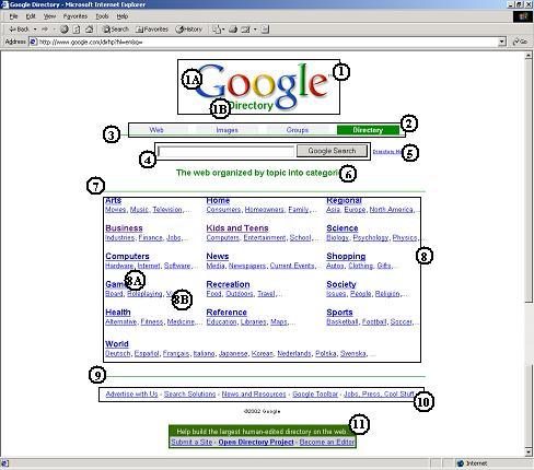
Figure 2: The Google Directory page (12-Mar-2002).
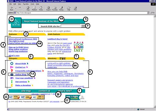
Figure 3: The Royal National Institute of the Blind (RNIB) home page (12-Jun-2002).
Table 2: Travel object inventory and classifications from the first evaluation (Google Directory page (Figure 2)).
| Object | Total | DP† | WE† | NP† | RP† | RPC† | LP† | DR† | DS† | ID† | AL† | AT† | IP† | TA† | TM† | TS† | |
|---|---|---|---|---|---|---|---|---|---|---|---|---|---|---|---|---|---|
| 1 | Logo | 10 | 10* | 2 | 3 | 5* | |||||||||||
| 1A | “Google” | 2 | 1 | 1 | 2 | 1 | |||||||||||
| 1B | “Directory” | 2 | 2 | 2 | |||||||||||||
| 2 | Main menu | 12 | 12* | 10* | 3* | 5 | 3 | 3 | |||||||||
| 3 | Line separator | 5 | 5* | ||||||||||||||
| 4 | Search box & go | 11 | 8* | 3 | 4 | 10* | |||||||||||
| 5 | Help link | 10 | 1 | 9* | 2 | 4 | 1* | ||||||||||
| 6 | Description | 8 | 3 | 1 | 4* | 5 | |||||||||||
| 7 | Line separator | 12 | 12* | ||||||||||||||
| 8 | Categories table | 12 | 11* | 11* | 4 | 1 | 3 | 2 | 1 | 3 | 3* | ||||||
| 8A | Category title | 4 | 1 | 4 | 2 | 2 | 2 | ||||||||||
| 8B | Category list | 3 | 2 | 3 | 2 | 2 | |||||||||||
| 9 | Line separator | 11 | 11* | ||||||||||||||
| 10 | Footnote menu | 12 | 10* | 11* | 1 | 3 | 1 | 2 | 3* | ||||||||
| 11 | Footnote | 9 | 3* | 6* | 3* | 2 | 6 | * | |||||||||
| Average (except 1A-B, 8A-B) | 10.18 (84.8%) | † See Table 1. * Potential roles of the travel objects. | |||||||||||||||
Table 3: Travel object inventory and classifications from the second evaluation (RNIB home page (Figure 3)).
| Object | Total | DP† | WE† | NP† | RP† | RPC† | LP† | DR† | DS† | ID† | AL† | AT† | IP† | TA† | TM† | TS† | |
|---|---|---|---|---|---|---|---|---|---|---|---|---|---|---|---|---|---|
| 1 | Logo & banner | 5 | * | 5* | 2 | 1 | 1* | ||||||||||
| 1A | Banner | 1 | 1 | 1 | |||||||||||||
| 1B | Logo | 1 | |||||||||||||||
| 2 | Search box & go | 6 | 3* | 2 | 2 | 5* | |||||||||||
| 3 | Features heading | 6 | 4* | 1 | 1 | 1 | 6* | ||||||||||
| 4 | Feature list | 6 | 5* | 2 | 6* | 1 | 2 | 3* | |||||||||
| 4A | Features sub-list | 1 | 1 | 1 | 1 | 1 | |||||||||||
| 5 | Hotspots heading | 6 | 4* | 1 | 1 | 1 | 6* | ||||||||||
| 6 | Hotspots list | 6 | 6* | 2 | 6* | 1 | * | 3 | 3* | ||||||||
| 6A | Hotspots item | 2 | 2 | 2 | |||||||||||||
| 7 | Directory heading | 6 | 4* | 1 | 1 | 1 | 6* | ||||||||||
| 8 | Directory list | 6 | 5* | 1 | 6* | 1 | 2 | 4* | |||||||||
| 8A | Directory sub-list | 1 | 1 | 1 | 1 | 1 | |||||||||||
| 9 | Site menu | 3 | 3* | 3* | 3* | 1 | 2 | 2 | |||||||||
| 10 | Site menu(text) | 3 | 3* | 3* | 1 | 1 | 1* | ||||||||||
| 11 | W3C approvals | 5 | 3* | 5* | 4* | 1 | |||||||||||
| 12 | RNIB logo (small) | 6 | 6* | * | 2 | 2 | |||||||||||
| Average (except 1A-B, 8A-B) | 5.3 (88.8%) | † See Table 1. * Potential roles of the travel objects. | |||||||||||||||
In both evaluations, some aspects were also investigated concerning the suitability of the framework for automated and manual implementation that will be encoded in our tool. The following issues are related to the automated implementation:
Similarly, the following issues from the evaluations concern the parts of the tool that will be handled manually:
Table 4: Time taken for analysing the first page (Google Directory) and the second page (the RNIB home page).
| Participant | Time (Google) | Time (RNIB) |
|---|---|---|
| P1 | 2:30h | 1:00h |
| P2 | 2:15h | 1:15h |
| P3 | 2:10h | 1:05h |
| P4 | 2:00h | 1:15h |
| P5 | 1:30h | |
| P6 | 1:10h | |
| P7 | 2:15h | 1:00h |
| P8 | 1:40h | |
| P9 | 3:00h | |
| P10 | 2:30h | 2:00h |
| P11 | 2:45h | |
| P12 | 3:00h | |
| Average: | 2:13h | 1:15h |
In both evaluations, although the participants did not have difficulties classifying the travel objects concerning the proposed classifications (see Table 1), the following suggestions and feedbacks were provided:
Consequently, we modified and extended the travel object classifications by concerning these suggestions and feedbacks. Finally, the following issues were also revealed from the evaluations:
As a conclusion, the hypothesis was confirmed. All the issues discussed above demonstrate that the framework could be used as the basis of our mobility support tool. We will be able to semi-automate the travel analysis process which is encapsulated in the framework. The process in the framework is consistent and systematic. It is rigorous enough to be used as the foundation of our mobility support tool.
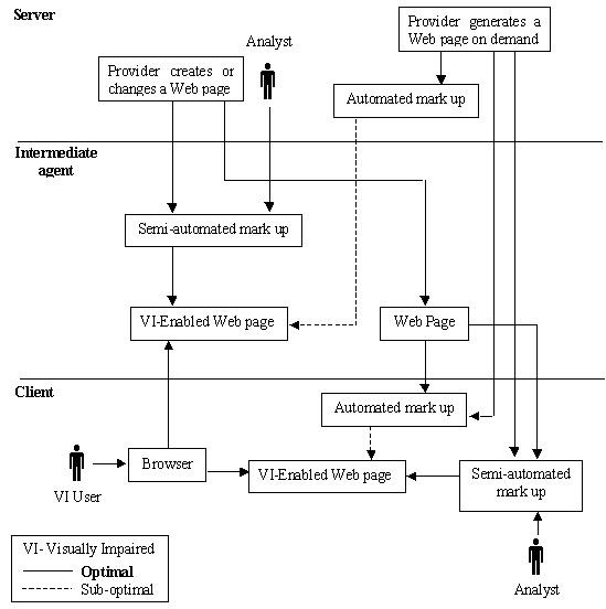
Figure 4: A flow diagram of the tool in use.
This paper has presented a travel analysis framework and discussed the evaluation of the framework. This framework is based upon a model of real world travel which has been presented and extended in this paper. This framework is used for identifying travel objects on Web pages and classifying them by concerning the roles of travel objects in the model of real world travel.
Our main goal is to improve the mobility of visually impaired users by providing tool support for the provision of mobility. The travel analysis framework will be the foundation of such a tool. The evaluation of this framework demonstrated that the travel analysis encapsulated in the framework is consistent and systematic. Furthermore, the evaluation showed that the framework is rigorous enough for being used as the basis of a mobility support tool. The tool will semi-automatically:
The travel analysis framework is dealing with the first two points, that is to say, it provides the platform that a tool can be build upon. The aim of the transformation is to improve the provided mobility support. In this paper, we have left the issue of annotation and transformation open on purpose, since it is the current focus of our research.
As a first step towards designing our tool, we set the context for the implementation and the usage of the tool. Figure 4 provides the overall context. The tool could be implemented and used on both the server side and the client side. It is more likely that it will be implemented on the client side. A Web page could be automatically and semi-automatically analysed and annotated. Both approaches have pros and cons. The automatic annotation might not deal with the subjective issues such as the navigation structure, however, may be efficient in time and effort because it does not require manual intervention. On the other hand, semi-automatic annotation might lead to accurate and optimal annotation and transformation. However, it may not be efficient in time and effort since requires manual intervention. Similarly, on the server side, the designer or the owner of the page can use the tool to semi-automatically analyse and annotate the page before publishing it. The automatic analysis can also occur on the server side, when a page is created on the fly.
As a conclusion, the next challenge is to encode the classifications and guidelines into heuristics. Establishing heuristics will lead us to the design and implementation stage of our mobility support tool.
Yeliz Yesilada gratefully acknowledges the scholarships awarded her by ORS and the Department of Computer Science of the University of Manchester. The authors would also like to thank all the participants for their enthusiasm and help during the evaluation.
[1] Wayfinding: People, Signs, and Architecture. McGraw-Hill, 1992.
[2] User interface of a home page reader. In The Third Annual ACM Conference on Assistive Technologies ASSETS'98, pages 149-156, 1998.
[3] Foundations of Orientation and Mobility. AFB Press, American Foundation for the Blind, second edition, 1997.
[4] Mobility and orientation process of the blind. In Proceedings of the NATO Advanced Research Workshop, pages 493-508, 1984.
[5] Beyond alt text: Making the web easy to use for users with disabilities. Nielson Norman Group, October 2001.
[6] Spatial orientation, wayfinding and representation. In K. M. Stanney, editor, Handbook of Virtual Enviroment Technology, chapter 28. Lawrence Erlbaum Associates, Inc, 2002. http://vehand.engr.ucf.edu/handbook/Chapters/Chapter28/Chapter28.html.
[7] Navigating large virtual spaces. International Journal of Human-Computer Interaction, 8(1):49-72, 1996.
[8] Route descriptions by visually impaired and sighted children from memory and from maps. Journal of Visual Impairment and Blindness, 92(7):512-521, 1998.
[9] The travails of visually impaired web travellers. In UK Conference on Hypertext, pages 1-10, 2000.
[10] User agent accessibility guidelines 1.0. World Wide Web Consortium (W3C), 1999.
[11] Web Mobility for Visually Impaired Surfers. PhD thesis, The University of Manchester, 2001.
[12] Towel: Real world mobility on the web. In V. J. and P. A., editors, Computer-Aided Design of User Interfaces II, pages 305-314. Kluwer Academic, 1999.
[13] Henter-Joyce, Inc. Jaws. http://www.hj.com.
[14] Improving the legibility of virtual environments. In Proceedings of the Second Eurographics Conference on Virtual Environments, Jan 31st-Feb 1st 1995.
[15] Navigation in electronic worlds: a CHI 97 workshop. ACM SIGCHI Bulletin, 29(4):44-49, 1997.
[16] Establishing and maintaining orientation for mobility. In B. B. Blasch, W. R. Wiener, and R. L. Welsh, editors, Foundations of Orientation and Mobility, chapter 2, pages 39-59. AFB Press, American Foundation for the Blind, second edition, 1997.
[17] The Image of the City. The MIT Press, 1960.
[18] Information Seeking in Electronic Environments. Cambridge Series on Human-Computer Interaction. Cambridge University Press, 1995.
[19] Wayfinding in Architecture. Van Nostrand Reinhold, New York, 1984.
[20] Wayfinding information for congenitally blind individuals. Journal of Visual Impairment and Blindness, pages 425-429, 1988.
[21] Wayfinding without vision; an experiment with congenitally totally blind. Environment and Behaviour, 20(2):227-252, 1988.
[1] Concepts are defined as mental representations, images or ideas [16].
[2] These objects are indicated as A and B in Tables 2 and 3.