As users get connected with new-generation smart programmable phones and Personal Digital Assistants, they look for geographic information and location-aware services. In such a scenario, developers need infrastructures and standards in order to provide geographic data and cartographic tools to a wide set of applications and small mobile devices. GIS market offers a rich set of powerful tools for geographic information management, but a simple and lightweight protocol to easily add cartographic functionalities to mobile applications is still missing. This paper presents the compact Geographic Markup Language (cGML), a custom version of GML tailored for mobile devices. By using small tags, server side pre-projected and pre-scaled coordinates, it allows development and deployment of map-based software for mobile phones and PDAs with strong constraints on connection, CPU and memory.
XML, mobile cartography, GML, J2ME
The diffusion of hand-held devices (like Personal Digital Assistant, PDA), new generation of programmable cellular phones (SmartPhone) and the availability of development environments for such devices have made possible the design and development of new kind of software. Mobile users require specialized applications for mobility support and personal information management. Many of such applications are specialized for geographic data management and cartographic presentations (i.e. navigation systems, interactive maps for tourism and commerce). Current mobile cartographic systems are based on ad-hoc approaches, tailored for a specific device. Moreover, they are stand-alone applications, aimed only to support user mobility. At the same time, software development for mobile devices and web applications is moving from digital mapping and travel assistant applications to Location Based Services (LBS) [3], in which content and information is filtered according to user position. The need for embedded maps into general purpose application is emerging.
There are mainly three approaches to mobile cartography implemented
in commercial products. A common solution is based on
native application and data installed on client device. Such an approach
doesn’t require any Internet connection: all data has been
stored locally on the device before the trip.
Another one is based on a web application: the user connects
to a web site which provides a form-based interface. The user can
specify a zoom factor, a search key and preferences about map details
but each result is always a static, non-interactive sequence of
images. Moreover, such an approach requires a permanent Internet
connection, in order to submit queries and get results.
The last one mixes the twos: the user browses the map service
using a PC and transfers final (static) map to the target device. During
his trip, the user doesn’t need an Internet connection but he will
not be able to modify pre-loaded map.
These three approaches share a common drawback: they are
stand-alone applications. They are not (nor can be) integrated with
other application, like an agenda or a address book. This is not a
issue for very specific applications (like professional cartographic
programs), but often a large set of mobile application need a simple
map-like representation of geographic data (and maps are only an
”accessory” functionality, not a must). A new scenario emerges:
simple maps should be retrieved remotely and described in a platform
independent format. Such a solution can be easily implemented
with web services technology and XML-based languages.
The Geography Markup Language (GML) is an open standard for encoding geographic information in a XML language defined by the Open GIS Consortium. It is not related to any specific hardware or software platform: data encoded using it can be easily read and understood by any programming language and software system able to parse XML streams. GML encodes vector geographical information together with metadata on spatial and non-spatial resources. GML can be easily converted in a different language using standard XML transformation facilities (XSLT). There are commercial and open source tools that translate GML data into SVG format, in order to display maps on standard plug-ins. Sometimes SVG is not suitable for target applications, since they need to access data model (GML) instead of getting a ”plottable” representation of such a model (SVG or other).
There are mainly two drawbacks in using GML for mobile devices.
First, it is memory- and bandwidth-consuming for storage
and transfer respectively. Moreover, maps described with it have to
be projected and scaled before being plotted. These characteristics
make the GML not directly accessible with small devices.
Starting from these considerations, we tried to customize and reduce
GML size in order to make cartographic data accessible from
mobile devices. Long GML tags has been substituted with shorter
ones (see Table 1). Output file remains human-readable, but considerably
smaller. At a first sight it could be considered a trivial
strategy, but it permits to reduce bandwidth and memory occupation
by 60%. Moreover, since it uses a static, well-known vocabulary,
no computation has to be performed to decompress incoming
stream.
| GML | cGML |
|---|---|
| FeatureCollection | FtCl |
| FeatureMember | FtMb |
| LineStringMember | LnStMb |
| coordinates | cd |
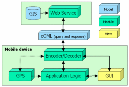
We have tested cGML on a web service that exports geographic data provided by a GIS service to a Java client. The client requests maps from the server by providing absolute coordinates of required area, name of layers and device profile. Query format is not complitely defined, we are still working on it and testing a templatebased approch, in which the client send a ”blank” cGML file as request. In order to test map data provisioning on real devices, two cGML engines has implemented, running on a PersonalJavacompliant PDA (Compaq iPAQ) and J2ME/MIDP enabled Smart- Phone (Nokia 7650) respectively. The former has been tested with a wireless 802.11b connection, while the latter used a GPRS connection. Both tests have shown that the adoption of cGML model optimizes bandwidth usage and improves rendering process (since no calculation must be done to plot the map on the screen).
Other works [2] has shown that map provisioning for mobile devices requires a complex infrastructure to be implemented. cGML can simplify application implementation and deployment, by means of XML-based language and web services infrastructure. In the field of User-Adaptative Maps [3], it has been shown that it is not enough to focus on adaptations to technical parameters (device characteristics, QoS, Location) but maps need to be dynamically generated according to a wider range of variables. cGML is on-fly generated according to device profile, but it can be tailored according to any other user (or device) property (specified in the query sentence).
GML provides an open standard to exchange geographical data but is not suitable for low-end mobile devices. We have proposed a compact version of GML (cGML), based on short tags and encoded with pre-projected and pre-scaled coordinates, according to target device profile. In our approach, it acts as model and view at the same time; data model can be totally transferred to client device for caching and local operations without a permanent connection to the server. cGML keeps some key features of GML: it is platform independent (while it is session dependent), easily extensible, human readable. It has been used in the e-MATE project [1], where it has been a key component in the development of multimodal location-aware distributed applications for wireless devices.